Geographical location and area of Nepal:
Nepal measures about 800 kilometers (497 mi) along its Himalayan axis by 150 to 250 kilometers (93 to 155 mi) across. Nepal has an area of 147,181 square kilometers (56,827 sq mi). Nepal is landlocked by India on three sides and China's Tibet Autonomous Region to the north. West Bengal's narrow Siliguri Corridor or Chicken's Neck separate Nepal and Bangladesh. To the east are India and Bhutan. Nepal depends on India for goods transport facilities and access to the sea, even for most goods imported from China.For a small country, Nepal has tremendous geographic diversity. It rises from as low as 59 meters (194 ft) elevation in the tropical Terai—the northern rim of the Gangetic Plain, beyond the perpetual snow line to some 90 peaks over 7,000 meters (22,966 ft) including Earth's highest 8,848 meters (29,029 ft) Mount Everest or Sagarmatha. In addition to the continuum from tropical warmth to cold comparable to polar regions, average annual precipitation varies from as little as 160 millimeters (6.3 in) in the rain shadow north of the Himalaya to as much as 5,500 millimeters (216.5 in) on windward slopes.
Along a south-to-north transect, Nepal can be divided into three belts: Terai, Hill, and Mountain Regions. In the other direction, it is divided into three major river systems, from east to west: Koshi, Gandaki/ Narayani and Karnali (including the Mahakali/ Sarda along the western border), all tributaries of the Ganges. The Ganges-Yarlung Zangbo/Brahmaputra watershed largely coincides with the Nepal-Tibet border, however, several Ganges tributaries rise inside Tibet.
Physical features of Nepal:
- Himalayan Region
- The great Himalayas
- Inner Himalayas
- Tibetan Marginal the Himalayas
- Hilly Region
- Midland
- Mahabharat Leks
- Churia Hills
- Terai Region
- Outer Terai
- Inner Terai
- Bhabar Tract
River-based division of Nepal:
Nepal is divided into three parts on the basis of the river:-1)Koshi
Koshi river lies in the eastern part of Nepal. The rivers such as Indrawati, Sunkoshi, Likhukhola, Dudhkoshi, Arun, Tamore and Tamakoshi are the tributaries of Koshi river. All tributaries mix together at Chatara after which the river is known as Saptakoshi. Koshi is the largest river of Nepal.
2)Gandaki
Gandaki river flows through the western part of Gandaki, Lumbini, Narayani and Baghmati zones. The tributaries of Gandaki are Kali-Gandaki, Seti, Madi, Marsyngdi, Budi-Gandaki, and Trishuli. When all the river mix together, the river is known as Sapta-Gandaki.
3)Karnali
Karnali rivers originate from Tibet. The tributaries of this river are Humla-Karnali, Mugu-Karnali, Tila river, Seti, Budi-Ganga and Bheri river. Karnali is the longest river in Nepal.
Administrative Division of Nepal:
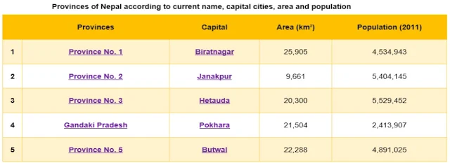
As of 20 September, 2015 Nepal is divided into 7 provinces. They are defined by schedule 4 of the new constitution, by grouping together the existing districts. Prior to September 2015, Nepal was divided into 5 Development regions.Fulfilling the requirement of the new constitution of Nepal in 2015, all old municipalities and villages (which were more than 3900 in number) were restructured into 753 new municipalities and rural municipalities. At present, there are 6 metropolitan cities, 11 sub-metropolitan cities, 276 municipalities, and 460 rural municipalities.
Nepal is composed of seven provinces. They are defined by schedule 4 of the new constitution, by grouping together the existing districts. Two districts, however, are split into two parts ending up in two different provinces.
Source: Wikipedia
(b) Summer: June - August,
(c) Autumn: September - November and
(d) Winter: December -February.
Spring is a colorful season which is punctuated by the odd shower of life-giving rain but the heat gradually builds until the monsoon relief arrives. During summer the Monsoon; moisture-laden wind, gathers in the Bay of Bengal and sweep up across India to spend its force on the Himalayan mountain chain. Autumn is renowned for clear skies and pleasant temperature.
By winter the high hills take dry brown shades and the mountains are occasionally dusted with fresh snow. However, due to Nepal’s vast range of diversified land orientation as well its amazing climatic variation effects regular seasons different and are six in Nepal.
Summer - Grishma June-July
Monsoon - Barsha Late June-Mid September
Autumn - Sharad September-November
Winter - Hinud December-January
Windy - Sisir February-March
Source: Wikipedia
Climate & Weather in Nepal
Nepal’s climate varies with its topography. It ranges from tropical to arctic depending upon the altitude. The Terai region, which lies in the tropical southern part of the country, for instance, has a hot, humid climate. The mid-land regions are pleasant almost all year round, although winter morning and nights are cool. The northern mountain region, around an altitude above 3,353 meters has an alpine climate with a considerably lower temperature and thin air in winter as can be expected.Nepal has four climatic seasons:
(a) Spring: March - May,(b) Summer: June - August,
(c) Autumn: September - November and
(d) Winter: December -February.
Spring is a colorful season which is punctuated by the odd shower of life-giving rain but the heat gradually builds until the monsoon relief arrives. During summer the Monsoon; moisture-laden wind, gathers in the Bay of Bengal and sweep up across India to spend its force on the Himalayan mountain chain. Autumn is renowned for clear skies and pleasant temperature.
By winter the high hills take dry brown shades and the mountains are occasionally dusted with fresh snow. However, due to Nepal’s vast range of diversified land orientation as well its amazing climatic variation effects regular seasons different and are six in Nepal.
Nepali Seasons:
Spring - Basanta April-MaySummer - Grishma June-July
Monsoon - Barsha Late June-Mid September
Autumn - Sharad September-November
Winter - Hinud December-January
Windy - Sisir February-March


0 Comments
If this article has helped you, please leave a comment.